Services
Depth Imaging Services
Advanced seismic depth imaging for structurally complex onshore environments
Thrust Belt Imaging was founded to help our clients reduce exploration risk in complex-structure land environments through seismic imaging. Where the data is robust enough to support the process, anisotropic depth migration offers the most accurate depths and lateral position of imaged reflectors.
Depth imaging as an interpretive process
Depth imaging on structured land data is an interpretive process. At TBI, we use a geologically constrained model building method, working closely with our clients to ensure we incorporate their domain knowledge into the process. We use our depth weathering solution (DWS) to merge our near surface model with the deeper structural model.
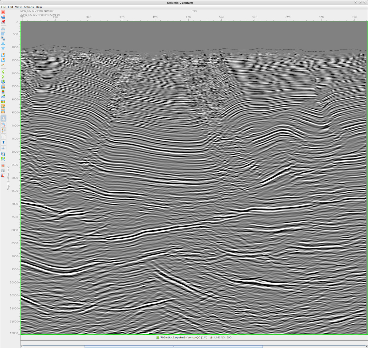
PSTM stack (converted to depth for comparison), showing imaging challenges in footwall underneath fault.
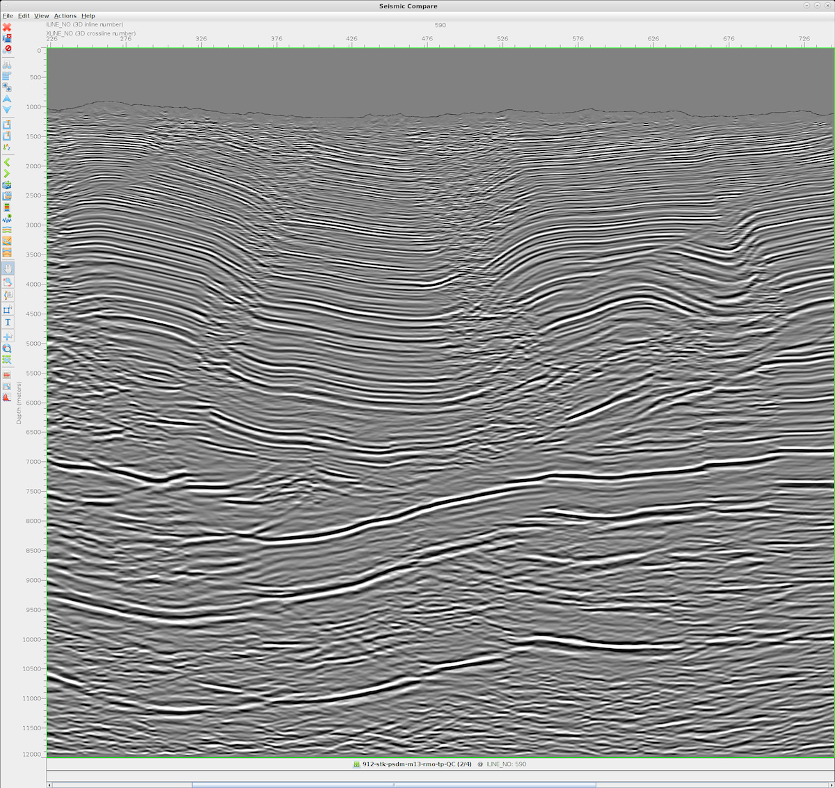
PSDM stack showing improved fault imaging, footwall geology, and reflector continuity compared to PSTM.
Advanced automated velocity model building
Velocity model building in structured land environments is both computationally intensive and geologically sensitive. To complement our interpretive, geologically constrained workflow, we have developed automated methodologies that increase efficiency while preserving structural fidelity.
These methods are specifically engineered to address the unique challenges of complex onshore datasets, where lateral velocity variations, anisotropy, and near-surface effects complicate conventional approaches.
Full Waveform Inversion (FWI)
Advanced Physics-Driven Velocity Updating
Our proprietary Full Waveform Inversion (FWI) uses an immersed boundary and novel wavelet matching to tackle the unique challenges of structured land data.
This implementation is designed to:
-
Handle complex structural geometries
-
Improve model convergence in anisotropic environments
-
Better align synthetic and observed wavefields
-
Reduce cycle-skipping risk in land datasets
Convolutional Neural Network (CNN) velocity prediction
Data-Driven Model Estimation Leveraging 20+ Years of Imaging Experience
Our Convolutional Neural Network (CNN) method uses training data that leverages our 20+ years imaging challenging data to predict a velocity model from migrated data.
This approach:
-
Extracts structural and amplitude patterns directly from migrated sections
-
Learns from historically validated models
-
Accelerates initial velocity model generation
-
Provides a robust starting point for iterative refinement
The CNN-based workflow does not replace geological interpretation; instead, it provides a computationally efficient foundation that is subsequently integrated with interpretive constraints.
Computer leveraged interpretive model building
We combine our automated methods with our geologically constrained model using our Computer Leveraged Interpretive Model Building (CLIMB) workflow.
CLIMB ensures that:
-
Automated inversion outputs remain geologically plausible
-
CNN predictions are validated against structural interpretation
-
Velocity updates are iteratively refined
-
Interpreter expertise remains central to the process
This hybrid methodology integrates physics-based inversion, machine learning prediction, and geological constraint into a unified, controlled workflow optimized for complex land data.